
Kilimanjaro. All you really need to do is say the word and it is instantly recognized worldwide. This stratovolcano, rising from the African savanna, is famous not only as the highest point in Africa, as one of the Seven Summits, and as the world’s highest free-standing mountain, but also as a formidable hiking challenge. The highest point on Kilimanjaro stands at a whopping 19,341 feet (5,895 m) above mean sea level! To climb such a massive mountain would indeed be quite the feat, and several colleagues of mine and I had discussed a trip there at some point to attempt this challenge.
Our opportunity arrived as part of a speaking tour I am involved with called ‘Sharing the Point’ that was sponsored by a phenomenal company called Colligo. The goal of this tour is to take a Microsoft technology I speak on called SharePoint into areas of the world where it has not had much of a presence. The first two tours took me and the team to Asia in 2011 and then later to South America and Antarctica, a trip I documented here in post on Buenos Aires, Montevideo, Santiago, and, of course, Antarctica.
So, as we thought through the itinerary of our trip, we pondered…”How do we beat the challenge of heading to Antarctica?” Quite simply…hike from near the base of a massive dormant volcano up to an altitude where there is less than half of the oxygen at sea level – a challenge indeed!
On this particular tour, called STP Africa, my colleagues and good friends Joel Oleson, Paul Swider, Mark Miller, and Eric Harlan joined me for the climb, with John Anderson supporting us from the base camp and serving as the official blogger for the event. Little did we realize what kind of physical and mental challenge we were about to undertake.
Preparation and the Arrival in Tanzania
If you ever travel with me, you’ll know I’m a bit of a stickler for logistics. I started planning this trip several months before hand and immediately realized that there was a lot more involved than simply making flight connections and getting hotel reservations in place. This type of adventure required the five of us that were involved with the hike to get in good physical (and mental) shape, and prepare our bodies for the shock of hypoxia (lack of oxygen.) We all trained in our own way; I headed up into the Sierras and once to Colorado to head as high as we could, and we all did a significant amount of hiking and walking in advance. The last thing we wanted to do was to have the mountain conquer us!
So, after months of training, we finally hit the road and started our tour of Africa. After stops in Johannesburg and Cape Town to kick things off, we headed off in the middle of the night back up through Africa to Kilimanjaro airport in Tanzania! After an arrivals process that involved purchase of a multi-entry visa ($100 payable at the airport,) some fingerprinting, and the exchange of dollars into Tanzanian shillings, we were ready to go!

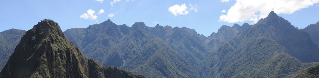
I actually wish I had enough space in this blog post to simply list the pictures I took on the drive from the airport to the city of Moshi, our base of operations. The pictures out of the window of the transfer van were amazing and made me wish we had more time to explore the region. Tanzania is a very distinctly East African place…reminded me most of Ethiopia, but also in many ways of Zambia and Zimbabwe. The scenes of rural life in the area were simply breathtaking. But, for better or for worse, we only had time in between speaking events for the hike itself, so we immediately headed to the hotel to gather our things, then left that same day to start the hike at Marangu Gate.
Day 1: Marangu Gate to Mandara Camp

Our hike took place on what is known as the Marangu Route up Kilimanjaro. This route, also nick-named the ‘Coca-Cola Route’ is the second most popular route up the mountain (recently surpassed in popularity by the Machame Route,) and is the only route that allows climbers to stay in huts as opposed to tents. You begin the hike at what is referred to as ‘Marangu Gate,’ at an elevation of 6400 feet (1970 m.)

The first day of the trip involves a relatively easy 5.5 mile hike through jungle-like vegetation for the majority of the way, up nearly 3000 feet to an elevation of 8858 feet (2700 m,) until you arrive at the first set of huts, known as Mandara Camp. Along the way is your best chance to catch some wildlife…we ran into several Colobus monkeys along the way (as well as an errant cow that we found wandering through the wilderness.)

Typically, hikers arrive at Mandara Hut relatively early in the day, but our aggressive travel schedule had us arrive just before dusk. We signed in at the camp registrar and were assigned a cabin for the night. Most of the cabins are A-frame units that house around 5-8 people, but we were assigned a room in a larger cabin that was divided into two separate rooms, one of which was inhabited by a group of Russian climbers from St. Petersburg. In short, don’t necessarily expect a cabin all to yourself, but it does depend on the size of your group.
Day 2: Mandara Hut to Horombo Hut

Day 2, 7:00am, and our guides wake us up to some hot tea and coffee. We eat some breakfast, then head out to get a start on a day that will involve much more elevation gain and a good 8 miles up to the next set of Huts. Along the way, the scenery starts to change and the jungle-like forest gives way to some very different alpine vegetation.

The advantage of the decline in the forest is that the sightlines become much more dramatic as we head out along the trail, and we start to catch glimpses of the peaks that lie ahead of us. Pretty much everyone is the group is feeling great, and we’re starting to feel like this may be much simpler of a hike than we expected, until the arrival of the ‘Kilimanjaro Express’ jars us back into the reality of our situation.

The ‘Kilimanjaro Express’ is effectively a makeshift stretcher that is attached to a bicycle tire on spring shocks. It barreled down the mountain past us carrying a hiker whose face had turned a horrible shade of blue…the tell-tale signs of hypoxia. The porters were whisking him down to lower altitude as quickly as possible, which is the only effective way of dealing with the oxygen deficiency. All of a sudden, we weren’t feeling so confident anymore, it was a real wake up call that was repeated one other time on our trip as well. I recalled reading that more people have died hiking Kilimanjaro than have on Everest, which is a sobering statistic to be sure.

After hours of hiking, and without warning, we rounded a bend in the trail and immediately caught a glimpse of our home for the next three nights…the ‘village’ of Horombo. When I say village, I really mean it…this is no small collection of huts, but rather a huge community of several hundred people: hikers, porters, guides, cooks, and medical staff. The place is a buzz of activity, with people coming and going, porters loudly chatting, and even impromptu games of checkers being played with plastic bottle caps.

The Horombo Huts are heavily occupied because they are the stopping point not only for hikers going up the mountain, but also for those coming back down. In addition, if you opt for the six day option, as we did, you spend an extra day acclimating here, so you get a wide range of folks at this camp. We had several interesting conversation with hikers from the UK, France, Russia, and the US, all at this site. We even ran into a group of a dozen Japanese hikers who had all summited successfully, and every single one of them was older than 70!

On that note, one of the most interesting aspects of this climb is that you immediately are close friends with nearly every hiker there, as you all have the same common enemy to conquer. People share stories of achievement, and on occasion share with you the grief of defeat. All along, those that made it provide advice to those that are headed up, and we all collectively lamented the lack of hot showers and decent meals. Give humanity a challenge and you’ll see us unite, I tell you!

Our second day complete, we stayed up to watch a spectacular sunset, then headed off to bed for the night. It was a colder night than the night before, and the diuretic properties of some of the high-altitude medications were getting to some of the team that had taken it, so we did not necessarily have the best night of sleep. All in all and speaking from backpacking experience, however, the huts were a definite improvement over tents.
Day 3: Acclimation Day

When you sign up for a climb on the Marangu Route, you have a choice between a five day climb and a six day climb. The difference between the two options occurs on Day 3. If you opt for the five day climb, you immediately head from an altitude of 12,204 feet at Horombo Camp and shoot straight up to Kibo Hut at an elevation of 15,429 feet. If, however, you opt for the six day climb, Day 3 becomes the ‘Acclimation Day.” The extra day helps your kidneys adjust to the lower levels of oxygen and greatly increases your odds of making it to the top.
 plants in the foreground.")
During the acclimation day, we left around 9am in the morning and took a short hike up through the forests of bizarre-shaped Giant Groundsels to an altitude at 13,222 feet (4030 meters) and the rock formation aptly named the Zebra Rocks.

It was an easy day for us, and a day to recharge our batteries and think ahead to the challenge which lay in front of us. The best, and most challenging part of the trip was yet to come.

Day 4: Horombo Camp to Kibo Hut

Day 4 of the Marangu route (Day 3 if you choose a 5 day climb) involves a steady climb from Horombo Camp to Kibo Hut, up to a whopping 15,520 feet (4750 m) of elevation. To put this into perspective, the highest point in the lower 48 states of the US is Mt. Whitney in California, at 14,505 feet (4,421 m.) On this day, you pass that point several hours into the climb and go even higher than that, just to get to the base of the main peak of Kilimanjaro itself!

The lack of oxygen becomes more and more apparent, and it becomes more of a challenge, even on the long stretches of relatively flat ground that you go across during the part of the hike that crosses the ‘saddle’ between Kibo and Mawenzi peaks, the two main peaks of Kilimanjaro.

After a hike of approximately 8 miles, you arrive at Kibo Hut, a camp nestled right up against the slope of Kibo Peak and that includes dormitory style housing with surrounding tent sites. Kibo Hut was our campsite for that night, if you can call it a night, as we were scheduled to wake up and tackle the mountain that evening at midnight.

There was an air of excitement, anticipation, and full-on trepidation here at Kibo Hut. We heard stories of some of the hikers being sent back from here, their oxygen levels considered to be too low for the climb. We met up with the Russians again here and found that one of them had a sensor that measured oxygen levels in the blood. Out of curiosity, most of us decided to see what our levels were…with a sigh of relief we were all above 80%. Any lower than this would be considered dangerous to continue.

That evening, we all watched a beautiful sunset paint the sky impossibly beautiful colors while lighting up Mawenzi peak, opposite from our camp. We turned to look Kibo at the trail leading up to our destination…it looked remarkably close by! Truth is, it’s only around 2 miles from Kibo Hut to Gilman’s Point, the rim of the crater. But what’s not immediately obvious is that you need to ascend over 3000 feet in that short distance before you reach that point, and then you have another 1.3 miles to go from there before reaching Uhuru, the highest point in Africa!

But we’ll worry about that tomorrow…er, tonight. For now, it’s lights out at 7pm and time to try to get whatever sleep we can before beginning the longest day of hiking and one of the biggest physical and menal challenges we’ve ever faced.

Day 5 – Part I: Summit Day!

Rise and shine, 11pm. Truth is, I was up earlier, as my mind was racing and thinking through strategy for the climb ahead. We drank some tea and cookies, put on every layer we had, flipped on our headlamps, and started on the long trudge up the switchbacks to Gilman’s Point.
It’s really hard to describe the first six hours of that hike that morning. It is pitch black, save for the light of a billion stars and headlamps that illuminate the trail. As you ascend, you see a snaking line of lights in front of you, and another line behind you. You slowly trudge by hikers that are keeled over, vomiting on the trail, and some who are sitting down motionless, looking as if they have lost the will to live. Others who have reached their limit are being helped down gently by their guides, a look of despair on their faces. It almost feels like a battleground, with casualties scattered on the side of the trail and very few words exchanged between people. All the while, you slowly put one foot in front of another, passing by the retching hordes, slowly taking yourself up higher and higher until the sky starts to lighten.

And then, suddenly, around sunrise, you reach the rim of the crater, to the place known as Gilman’s Point, at a whopping 18,638 feet (5681 m.) Here, you are ‘officially’ at the top of the mountain, though not quite at the highest point. A sign designates the spot, and congratulates you, but the sentiment is more or less lost on you as you understand that you still have several more hours to go before you make it to Uhuru Peak, the penultimate destination.

What is often described as the most beautiful sunrise in the world takes place up here, and the unfortunate part about it is that you really have little time to enjoy it. Your guide hurries you along and, to be honest, I personally simply wanted to get to Uhuru, so I hustled along and continued along the trail, along the rim of that massive volcano, up the last several hundred feet of altitude and another 1.3 miles.

As the sun rises, the landscape starts to slowly reveal itself. And what a landscape this is…volcanish ash, crazy rock formations, and ice fields hugging the peaks.

Along the way, you pass the spot called ‘Stella Point,’ which is where the hikers from the Machame, Lemosho, Shira, and Umbwe route reach the crater rim. You can most definitely tell that this trail is a popular one, it was shocking how many people were ascending at the same time here.

The trail continues along the rim passes very close to the Southern Icefields as well, which take on a mottled look due to the continuous melting that takes place. Indeed, our day at the top involved temperatures that were above freezing, and you could literally see the melting taking place all around you. It is most definitely true and sad that the ‘Snows of Kilimanjaro’ will not be here for much longer.


Sadly, if you want to understand how quickly the glaciers on Kilimanjaro are melting, compare the image above of the last remaining portion of Furtwängler Glacier with this photo taken of it in August of 2003. You can see an obvious difference, the glacier itself has completely split in two and shrunk considerably in size. This fact is, ironically, quite chilling, and it is sad to note the fast departure of these enormous and long-lived icecaps. After all, we all noted that the icecaps themselves were one of the most scenic and interesting parts of the summit climb itself and, without them, Kilimanjaro wouldn’t be the same.

In sight! The tell-tale green sign indicating Uhuru peak is visible as you get closer. This last several hundred feet feels like an eternity, and it doesn’t help that the lack of oxygen really starts to hit you at this point. Not to mention the fact that it was right around here that I passed a hiker who had gone blind (temporary hypoxia blindness) and had to be helped down by two porters.

That’s it! We made it! An odd feeling, almost anticlimactic. I mean, all there really is at the top is a large sign announcing your arrival. We all take our turns posing with the sign, which can be quite the challenge with the hordes that are there. Unless you arrive quite early, you can pretty much expect to share the peak with a large number of other folks.
This is really your first opportunity to step and look around you, revel in the moment, and take pictures from the highest point in Africa. I felt fantastic at this point, my adrenaline kicked in, and I took in the moment as much as I could.

Maybe it was the oxygen deprivation, but there was almost a sense of euphoria, and I found myself thinking about my life, my family, and the things that are important to me. I think there is something very introspective about taking on a challenge like this, it really makes you take stock of the important things.

Our victory was short-lived, however. After less than 30 minutes, our guides rushed us off of the peak. They were noticeably concerned that we were spending too long at the top, and wanted to ensure that we got some thicker air into our lungs quickly. It was then that it really hit us that we still were only halfway through our adventure, and we had to retrace our steps all the way back down to Marangu Gate.
 Joel Oleson, Eric Harlan, Michael Noel, Mark Miller, and Paul Swider at Uhuru Peak, Mount Kilimanjaro")
Day 5 – Part II: The Long Descent
 descending from the top of Mount Kilimanjaro, Tanzania")
Heading down the mountain is, of course, easier than heading up it, but in a way it is mentally more challenging. The adrenaline has worn off, and your body really starts to feel the effects of the oxygen depravation. We headed down quickly, spurred along by our concerned guides.

I had a few more opportunities on the way down to marvel at these icecaps as well, and to note the obvious signs of melting, such as the pool of water that formed at the top of Rebmann Glacier.

It takes a surprisingly long time to get from Uhuru back to Gilman’s Point, and you become acutely aware of the fact that your body is not receiving the oxygen it requires. To make matter’s worse, you aren’t really dropping much in altitude until you get beyond Gilman’s Point, which makes it that much more challenging to keep up a good pace.

But, inevitably, you make it back to the sign that marks the spot of Gilman’s Point, only this time with much more daylight to light your way. Coming up to the rim, you glance down, and see this…

Two miles away, and over a half mile down, lies Kibo Hut, and you need to go back down that impossibly steep trail. Did we really climb this last night? Daylight provides a very different perspective to the landscape, and you begin to realize the logic in having people climb this portion in the dark.

At this point, all that was going through my head was the need to get to lower altitude quickly, and fortunately for me, the most ideal way to get down this slope is to ‘ski’ it. Depending on your comfort level, you can jump and slide down the slope as if you were skiing in deep powder. It’s quite the experience, and you can really go fast if you push yourself to do so.

Do be warned, however, that the faster you go, the more likely you are to find some hidden rocks underneath the loose scree, and ‘wipe out.’ This happened to me once, though it was more of a ‘controlled’ wipeout, to be fair. To be honest, I was willing to take some risks to get to lower altitude, as each leap I took put more oxygen into my lungs.

Halfway down, you reach Hans Meyer Cave, which we passed during the wee hours of the morning earlier that day. Past this point, the scree field levels out a bit and becomes more difficult to ‘ski’ down, but you can still get a good head of steam going if you push yourself.
Roughly an hour from when I started at Gilman’s Point, I arrived back at Kibo Hut, in the front of the pack. It was not that I wanted to get there first, but I was driven by a constant urge to get down to lower oxygen as quickly as I could, which helped to propel me forward.

You typically have a chance for a quick nap here at Kibo, depending on when you arrive. I got down around 10am, and napped for a few hours until just after noon. At that point, your guides force you up again, still concerned to make sure you get down even lower by the end of the day. Wresting your sore legs out of bed, you head off from Kibo back across the Saddle and down from whence you came.

And finally, back to Horombo. At this point, the 12,000 foot air feels as thick as it is at sea level, at least compared to what you just went through. Glancing back at Kibo peak, it seems so far away and so impossible that less than ten hours earlier you were standing there at the summit.

Exhausted, our team went to bed early that night, with several members even eschewing the meal offered to us. I was able to eat at least a little, however, but as soon as dusk arrived I too was heading off to the hut for the final sleep here on the mountain. Perhaps it was the exhaustion, but we all had the best night of sleep on the entire trip that night.
Day 6: Final Descent to Marangu Gate

Day 6. It all almost felt like a dream. While elated, we were also extremely tired of the food (I still get sick thinking of millet porridge) and all felt like we just wanted a nice hot shower and some new clothes. While the day’s hike was long, we hit the trail early and steadily descended through the same terrain we saw on the way up.

As Kibo peak dissapeared from view, we took a brief moment for a group shot. On a personal note, I’ve known many of these guys for years, and got to know them even better after this trip. It’s not always easy to travel in difficult circumstances with people, but I’d travel anywhere in the world with this crew!
 Joel Oleson, Mark Miller, Eric Harlan, Paul Swider, and Michael Noel with Kibo Peak in the background after a successful summit attempt in September, 2012")
Before we knew it, we passed by Mandara Camp. It seemed like an eternity ago that we were here, fresh-faced and ready to take on the mountain. We stopped here for no more than five minutes before dusting ourselves off and heading down through the forest. We were ready for this adventure to end.

We quickly descended further into the jungle, spotting a few more monkeys along the way and running into a few poor souls who were heading in the opposite direction. It was only a few short days ago that we were in their shoes, but we were quite happy to be the ones heading in the other direction this time.

And just like that…it was over. Marangu Gate, the simple A-frame passage which marked the start of our journey, now signaled the end of it as well. We had made it…over 50 miles of hiking, an elevation gain and loss of over 13,000 feet each way, and six days of sweat and tears. Yes, it was a challenge, but in ways I hadn’t fully anticipated. The physical aspect of it was rough, to be sure, but it was more of a mental challenge than anything. The reality is that we all learned something about ourselves on this trip, and I personally developed a healthier respect for humanity and what we can all accomplish, given the right challenge and the right group of friends to pursue that challenge with. And, while a trip I’ll never forget, it’s not something I’d want to do again…at least not for quite some time.

Our STP Africa tour did not end here. After our ascent of Kilimanjaro, we immediately headed out to Nairobi that night to speak at another STP Africa event the next day. But that’s a part of a different blog post!
For those interested in climbing Mt. Kilimanjaro on the Marangu Route, there were a few key points I wanted to address in closing. These are all critical pieces of information that I would have loved to have had before I went on the climb, but were not obvious from reading about the climb online.
- Do NOT overpack. This is the single most common mistake most people make, according to our guide. My ‘day pack’ consisted only of a Dakine hydration pack that I could wear on my waist, and the pack containing my additional gear that the porters carries only weighed around 20 pounds total. You really don’t need much, and it is a huge pain to bring it all to Tanzania. If you pack lightly…you will be much more likely to be able to fit everything into the overhead bin on an airplane. I overheard several people in a panic on their phones at the hotel in Moshi whose critical gear went missing while in the hold of their respective flights, so it’s critical that you pare your list of gear down to the bare essentials.
- You may want to consider bringing on some type of ‘comfort food’ on the trip. You will get tired of the food you are provided very very quickly. Don’t take this too far, however, see note #1 above.
- Take care of your boots, and don’t skimp on them. 50 miles over the course of the week will expose ANY weakness your boots may have. I recommend Asolo Power Matic 200 waterproof boots, which are what I wore on the trip. More expensive, but the best investment you’ll make on your climb. I wore those boots everywhere on the trip, and never once had to apply moleskin or bandages to my legs. And make absolute sure you have them broken in before you climb!
- Second after boots in priority should be your own sleeping bag, otherwise you’ll be renting a ‘used’ sleeping bag that will get quite cold at night and might be quite unhygienic. I brought along my North Face Superlight sleeping bag, which allowed me to sleep in toasty warm comfort, even at Kibo Hut. Cold rented sleeping bags were one of the main complaints of my colleagues.
- Yes, there is indeed mobile phone coverage on the climb! You can catch a decent signal if you stand still outside at Mandara Hut and there is spotty coverage at Horombo Huts that gets much better on clear days. Getting out calls and texts was not too difficult from these two locations, and on a few spots along the trail, but data was spotty. I was, however, able to send out a few pictures along the way and sync emails a few times. I also actually got some data in while hiking down the scree field on the side of Kibo, but you completely lose signal at Kibo Hut.
- I didn’t take any Diamox medication to assist with the high altitude, though many people I talked to did. I did not personally find a difference between the success criteria of those who took it versus those who didn’t take it. My take is that the best thing you can do is add acclimation days to your agenda rather than taking the medication.
- I HIGHLY recommend a stop in Zanzibar after you are done with your climb. We traveled there shortly thereafter, and were very happy we did.
Finally, I’ll leave you with links to some of the blog entries my traveling companions wrote on the same trip. Thanks for visiting!

Pingback: Zombies on Kilimanjaro – My Trek on the Marangu Route | Traveling Epic
Hi there, just a word of thanks: we were there end Dec, and made it to Uhuru. I got AMS early on, got better, and was fine on summit day. I had a 3D camera with me and made wonderful pix (3000 of them, to be precise), yet unfortunately, on the way down from Gilman’s to Kibo, I was so spaced out that I “forgot” to take pictures… So I plucked some of yours to plug the gap… Cheerio, all the best for 2013, happy hiking! PhB